Resources

Friday, September 18, 2020

Update: mid-September wildfire potential

We've reached mid-September and have experienced all 4 season in the past 2.5 weeks. Where does that put us in terms of wildfire potential for the rest of the month?

In short, the rest of the month looks to be warm and dry with numerous dry cold fronts to bring us wind. To me, that spells enhanced fire potential. 

Let's look at the precipitation we have received. 

The past 30 days:


The past 7 days:

Over the past 30 days, most of the state has been drier than average. This time period does encompass our rain/snow event over Labor Day. It brought 1-2 inches of moisture to the central and northern Black Hills as well as portions of central SD. But since that time we have been exceptionally dry especially across western and southeastern portions of the state. The lack of recent precipitation tips the scales towards higher wildfire potential for the rest of the month. 

The lack of precipitation has allowed the drought situation to continue. Over most of SD, drought is well-correlated to an increase in wildfires during September. 


Looking ahead, dry and warm (actually hot) conditions are expected in both the short term and long term. The maps below are the current 6-10 day forecasts for temperature (top) and precipitation (bottom). This pattern continues for the 8-14 day outlook and the 3-4 week outlook. 

Fuels are becoming even more available as the grasses become fully cured with the seasonal dry down. The grasses were struggling to begin with as the lack of moisture over the past few months has led to dry conditions. The Vegetation Drought Response Index (VegDRI) below shows how the drought has affect the vegetation. 

The forecast weather models are showing an active pattern continuing through the rest of the month with several cool fronts (I'd call them cold fronts but the air won't really be that seasonally cold) moving through the state each week through the end of the month. Wildfires tend to grow big in September in the vicinity of a cold front. Remember, just ahead of an impending cold front temperatures are typically well above average with dry and gusty southwest winds. Then as the front passes, the temperature may drop but with dry cold fronts the RH tends to remain low as gusty northwest winds increase. 

The highest wildfire potential remains over southwestern SD but the entire western half of the state has higher-than-average potential. East River areas are a mixed bag but with agriculture activities progressing, there will plenty of opportunity for new fire starts and a big fire or two cannot be ruled out. 

But on the bright side, we may have some good opportunities for prescribed fire! Burn windows are short and the days with less wind may bring optimal RX conditions. 


Thursday, June 11, 2020

Black Hills precipitation updates

Precipitation across the Black Hills continues to lag behind seasonal averages. We did have a few strong/severe storms move through the area June 3 - 6 and those storms brought locally heavy rain. But the rain was not widespread and it fell hard meaning much of it was "lost" to runoff and was not able to efficiently soak into the soils.

Below are several graphs showing precipitation for different stations across the Black Hills. All graphs show precipitation received from April 1 through June 10 and are compared against their historical average at that location.

Southern Black Hills:


Central Black Hills:


Northern Black Hills:


As you can see, every station is lagging behind seasonal average for this time of the year. Don't forget that April, May, June, and July are our 4 wettest months of the year for this area. Precipitation deficits now set the stage for potential drought conditions down the road. 

What is in the forecast?
In the near-term, we look to remain dry. The Weather Prediction Center is only showing light accumulating precipitation over the western Black Hills over the next 7 days. This rain will likely come Saturday evening/night when a few thunderstorms rumble across the area. 

Good news though: the GEFS ensemble models during the time period from June 20 through June 27 are showing above-average precipitation for western SD. There is hope on the horizon at this point!

Tuesday, June 2, 2020

Wildfire an increasing concern for the summer

A month ago I was hopeful that we would see low wildfire potential over our summer wildfire season. However, the conditions that we have been experiencing recently are changing my thoughts.  

[But first, I need to say that I am really referring to western SD here. Summer brings a peak of wildfire activity to this area. This is opposed to eastern SD where wildfire activity peaks in March/April.]

Precipitation:
April and May are two of the four wettest months of the year over western SD. For Rapid City, Custer, and Philip these two months account for 30%, 28%, and 33% of the annual average precipitation, respectively. This is also the time of year when herbaceous plants (fine fuels and the carrier of wildfire) need the moisture to begin greening up. If greenup is delayed, stunted, or doesn't occur, the plant material is more susceptible to carrying fire.  

Large precipitation deficits have been observed over western SD during this period. Many stations have only seen 50-70% of the average precipitation. 


Temperature:
Hot temperatures create more evaporative demand which pulls moisture from the soils and plants. The big thing we haven't seen over the past two months is hot temperatures. In fact, temperatures have actually been cooler than average by several degrees. 


Even though we haven't had much for precipitation, the evaporative demand has been lower due to cooler temperatures which then reduces the stress on the plants. We can track this through the Evaporative Demand Drought Index (EDDI). The EDDI values for South Dakota are not showing any issues with dryness. 
So you could say that less precipitation than average combined with cooler than average temperatures has the net effect of "average" with regards to our evaporative demand. This is a good thing and it is the primary factor that is keeping me from being overly concerned about our summer wildfire potential at this point. 

Fuel moisture:
One metric to characterize drought is the 1000-hr fuel moisture. The southwestern Black Hills (Red Canyon), southeastern Black Hills (Custer State Park), and the central Black Hills (Baker Park) RAWS stations all show a 1000-hr fuel moisture that is drier than average. Thanks to Jay Wickham from SDWF for putting these together. 


So the big dead fuels in at least the central/southern Black Hills are relatively dry. 

Soil Moisture:
Yes, the past two years have been very wet across the region and soils still remain wet over South Dakota. But by looking at the change in soil moisture anomalies, we can see that things are drying out considerably. Without additional rain, evaporation and transpiration can tap out that residual soil moisture and we are heading in that direction. 
Greenup:
How has greenup been progressing so far? It seems to be slower than average. The Vegetation Drought Response Index (VegDRI) combines a variety of metrics to measure the vegetation conditions. For South Dakota, is is showing dry over most of the state. 

One of the variables going into VegDRI is the NDVI which measures the 'greeness' of the vegetation as compared to an average. I hypothesize that our fuels are more 'brown' than usual due to the lack of recent precipitation and the cooler-than-average temperatures that may be delaying greenup. Contrast the image above to the one from this time last year when things were very wet and very green. 
It is a very different picture in 2020 than it was in 2019. 

So what is in the forecasts?

The Climate Prediction Center (CPC) creates monthly outlooks for both temperature and precipitation. These forecasts become a cornerstone of the forecast process that wildfire meteorologists use to create seasonal outlooks. If the CPC forecasts leans towards cool and wet, we tend to hedge our bets towards lower wildfire potential. If the opposite is true, it might mean more wildfire activity. (Of course there are many other factors at play when considering wildfire potential.) The CPC is forecasting good odds at a hot June with no signal one way or the other for precipitation:
 

Again, I go back to evaporative demand. If this CPC forecast verifies, the hot temperatures will increase evaporation leading to more stress on the plants. Without accompanying moisture, we could see earlier curing of the fuels. 

Summary:

My research has shown that positive temperature anomalies during June combined with precipitation deficits in April-June favor large wildfire activity in June and July. I must caveat this, however, with the fact that long-term drought (as given by the Palmer Modified Drought Index [PMDI]) is also well-correlated to big fires during the same months and our current PMDI values remain quite wet. 

Back in late April, I was hopeful that May/June were going to bring ample rains which would reduce our wildfire potential over western SD. Since we have not seen those rains materialize, our threat for bigger fires has increased. Furthermore, the forecasts for a hot June tilt the scales towards more fire activity as well. 

I know 2018/2019 were two the of the wettest years on record in SD but things have changed in 2020. And we need to recognize that and plan for it. Be ready and don't let this unfolding situation catch you off guard. 


Monday, March 30, 2020

Fire Weather on Tuesday, March 31, 2020

I expect elevated fire danger tomorrow, March 31, 2020 across much of southwestern SD due to the combination of warm temperatures, low RHs, and gusty winds. The one thing going for the area is that it did get good moisture late last week but it has been dry since Saturday. These aren't going to be absolutely critical conditions but I do think fires will easily spread if ignited.

Here are the forecast graphics from the Rapid City NWS office:


These show forecast maximum temperature, minimum relative humidity, and maximum winds gusts for the 31st. Southwestern SD is definitely drier than the surrounding areas, hence my thinking of higher fire danger there. But I also think it is going to be drier and windier than what these images show, especially over Fall River, eastern Custer, eastern Pennington, Oglala Lakota, Bennett, Mellette, Jackson, and Todd Counties.

Below is a forecast skew-t/log P diagram for 43.0 N and 103.5 W, roughly near Ardmore, SD. The top image is from the 12Z GFS run from this morning forecasting the thermodynamic profile for 18Z tomorrow. The bottom image is the same except for it is from the HRRR weather model. The profiles are very similar to each other, except for that the HRRR keep dew points lower and temperature higher across the area. This would bring lower RHs than what is forecast currently by the NWS (which lean towards the GFS dew point solution). Lately, the HRRR has been more accurate in depicting dew point than the GFS. The other thing to note in both forecast images is that there is a relatively deep mixing layer with strong unidirectional winds extending 6-7 kft above the surface. Deep mixing may very well lead to winds gusts in excess of 30 mph over the area.
The caveat with forecasting for a deep mixing layer is cloud cover. Both soundings show midlevel moisture which may be realized in the form of altostratus clouds which could kill daytime heating and prevent deep mixing from occurring. If this happens, conditions will not be as warm, dry, or windy as would be if the clouds were not present. I also see some conditional instability in the soundings so don't rule out a thunderstorm either. Lightning can ignite fires!

Let's take a look at the HDW index as well for that same area.
You can see that the HDW, for all ensemble members, is above the 90th percentile. So this is historically a rather hot, dry, and windy day. But the HDW is based upon the GFS ensembles which may suffer from the same issues that the GFS does--too moist in the lower levels. It may be drier than what this graph represents.

It is a tough forecast but I am hedging my bets towards warmer, drier, and windier than what is currently in the NWS forecast products. Stay aware out there and don't be surprise if you see critical fire weather conditions on the ground.

Look for a strong cold front to push through Wednesday with accumulating snow across the state on Thursday and Friday which will effectively end this period of higher fire danger.

Tuesday, February 25, 2020

Rapid City Snow 2/24 -2/25/2020

Rapid City saw a substantial snow event that spanned from February 24 through February 25.

The National Weather Service in Rapid City was calling from 3-6 inches of snow in town at 2:11 am on 2/24/2020. They noted in their 2:32 am forecast discussion that the potential for upslope snow in Rapid City was increasing and that the moisture was higher than previously forecast, both of which could bring higher snowfall totals. Their forecast discussion at 1:49 pm from 2/24/2020 mentioned that the snowfall forecast for Rapid City "will be tricky, as it will depend greatly on where upslope enhancement occurs." They went on to say, "the Froude number, along with lack of inversion in the soundings, suggest that the upslope enhancement may produce more snowfall over the central Black Hills, rather than the Rapid City area." At 3:22 pm, the NWS upped their snowfall forecast for Rapid City to 5-7 inches but it was obvious that plenty of uncertainty remained in the forecast.

Various weather models were showing snowfall totals as given below (1200 UTC model output from 2/24/2020 with 36 hour forecast snowfall totals given for both 10:1 snow and Kuchera snow ratios; ranges due to snow gradient across Rapid City).

Model: 10:1 ratio, Kuchera ratio
GFS: 3-5 inches, 5-9 inches
HRRR: 7-9 inches, 8-10 inches
NAM: 5-7 inches, 7-10 inches
ECMWF: 5-7 inches, Kuchera N/A
NAM 3km: 7-10 inches, 8-14 inches

The 18 UTC model output for a 30-hr forecast (to compare with the previous 36 hour forecast):

Model: 10:1 ratio, Kuchera ratio
GFS: 4-7 inches, 6-9 inches
HRRR: 4-7 inches, 6-9 inches
NAM: 5-7 inches, 7-11 inches
ECMWF: N/A
NAM 3km: 5-8 inches, 6-10 inches

All considered, there was fairly good consistency among the weather models for a forecast snow total of more than 4 inches but generally less that 9 inches when considering a 10:1 snowfall ratio. The Kuchera method takes a different approach using information on the thermodynamic profile to get a snowfall ratio that can change with time. As snowfall during colder temperatures can bring snowfall ratios on the order of 20:1 or 30:1, using the Kuchera method can give some idea on how much snow to expect if a non-10:1 ratio is possible. This Kuchera method for this event gave snowfall totals generally from 6 to 10 inches., with ratios ranging from 10:1 to 16:1.

My forecast for snowfall in Rapid City ranged from 4-9 inches. I was assuming that there would be a fairly tight gradient of snowfall across the city due to localized upslope enhancement. I was figuring northern/northwestern Rapid City was going to see 6-9 inches while southern Rapid City down through Hermosa was in the 4-6 inch range. There were caveats to the forecast, as the NWS had mentioned, but more than 10 inches of snow from an Alberta Clipper-type event seemed unlikely.

What happened was that we got ~50% more snow than expected. The map below is as of 11:30 am on 2/25/2020. Note that some stations reported their snowfall totals at earlier times and have not updated as of this writing. Find current snowfall information here: https://www.weather.gov/source/crh/snowmap.html?sid=unr

Why?

Obviously this is a tough question to answer. But I've got a few ideas:

  1. Convective snow showers were present over the region. This likely led to higher snowfall totals in those areas beyond what was forecast in the models due to differing dynamic processes at play. 
  2. Additional mid-level moisture. Water vapor imagery continued to show high levels of mid-level moisture advecting into the region through the snow event.  
  3. Localized mesoscale banding. There were several bands of precipitation that set up during this snowfall event. Although the models were consistently showing some banding, the precise location where they occurred may not have been properly forecasted. The HRRR model was showing one of these bands east of town through several model runs. Radar imagery from overnight shows a band of heavy snow directly over Rapid City for 5-6 hours in the early AM. Miles matter but the weather models are not capable of perfectly resolving where these bands will set up.  
  4. A system slow down. The main forcing for the snowfall appeared to stay over Rapid City longer than what had been forecast by the models. Snowfall totals are determined by: the rate of snowfall x the duration of the event.  
Our weather models are a diverse and valuable set of tools but we must remember that they are only numerical representations of the atmosphere. They provide meteorologists with exceptional guidance, but they are, by nature, imperfect.

Next time I see a similar scenario like this where Rapid City will see a period of northeasterly upslope winds and the potential for convective snowfall, I will likely lean towards the higher-end of the model guidance for snowfall accumulation.

Tuesday, January 21, 2020

Dry down over western SD

The prairies of western SD and the southern Black Hills are starting to see the effects of a short-term lack of snowfall. The snow depth has gone to zero in many areas leaving exposed fuels across the landscape.


Listed below are the number of days since the last precipitation event of greater than 0.10" for selected cities. 
Rapid City: 11
Custer: 25
Pine Ridge: 25
Philip: 11
Hot Springs: 25
Buffalo: 53

In January, wildfires across western SD occur with little or no snow pack after a period of several weeks without a wetting precipitation event (greater than 0.10" of liquid equivalent moisture). Above average temperatures and strong winds are also common when big fires do occur. 

The recent dry spell and periodic warm temperatures has taken a toll on the lingering snow. More fuels are now exposed to the dry winter air and are becoming available to carry fire. 

Keep an eye on the forecast and if we see days with strong winds and warmer temperatures, don't be surprised if we do see a few wildfires. 

Wednesday, September 25, 2019

Hot, dry, and windy on Thursday, 9/26/19


Highlights:

Near-critical fire weather conditions are possible over southwestern SD tomorrow. A strong cold front will then move through tomorrow evening.

Discussion:
We are expecting a hot, dry, and breezy day tomorrow across Fall River, Custer, and Oglala Lakota Counties. Temperatures are expected to reach the mid-80s, minimum RH will drop into the 13-20% range, and west-southwest winds from 10-20 mph are likely with gusts to 30 mph possible. 

A dry cold front will then move through the state tomorrow evening. This will bring a period of breezy northwest winds, gusting to 20-35 mph over southwestern SD. Keep this evening wind shift in the forefront of your mind if there is an ignition. Cooler and more humid conditions will prevail on Friday with the breezy northwest winds continuing through midday. Showers are expected Friday night and Saturday.

Fuel conditions are not yet critical but the Cottonwood Creek fire last week (9/17) did grow to 57.54 acres showing that there is some potential for fire growth in that area of the state. Quoting Jay Wickham from Monday’s Weekly Weather Update, “There are some areas in the southern Black Hills where the grass has cured but most of the herbaceous vegetation will probably remain green until we receive some hard frost.  Wind will be the driving factor for any fire to be able to spread.” The neighboring counties in WY are under a Fire Weather Watch for Thursday but no Fire Weather Watches or Red Flag Warnings have been issued by the NWS for areas of SD as of yet. 

Tuesday, September 17, 2019

Lightning today and tonight


Showers and thunderstorms are moving through portions of the Pine Ridge Reservation. Additional showers and thunderstorms are now moving into western SD from WY. These storms are moving quickly to the north-northeast, are producing frequent lightning and gusty winds, but are not putting down much in the way of rain. I expect these storms to continue through the evening.


The fuels are not yet favorable for large wildfire growth but it wouldn’t surprise me to see several ignitions from this event. Watch for holdovers in the coming days as well.

Friday, August 2, 2019

August fire potential very low

July has come and gone and it was another wet month across SD. Nearly every location statewide received a surplus of moisture mitigating any wildfire concerns for the month. Some areas even saw 4-6 inches of moisture above the monthly average!
The recent rains combined with the forecast for cooler and wetter than average conditions should keep us clear of any large wildfires through at least the month of August.

You can find my full monthly assessment here: http://www.ias.sdsmt.edu/clabo/Fire_Weather/Monthly_Update.pdf

Wednesday, July 10, 2019

Impending hot weather and fire danger

A large upper level ridge will set up over the Rocky Mountain Region in the near term and this will bring above average temperatures to large swaths of the central and northern Great Plains as well as the Rocky Mountains.

Generally, above average temperatures in mid-July would concern me as a fire meteorologist. But conditions are still not favorable for large fire growth. To get large wildfires across SD, including the Black Hills, during July we need to have several elements in place:

1. Drought conditions (or long-tern precipitation deficits). Drought leads to dry soils and the desiccation of the larger fuel classes. However, we do not have drought or even abnormally dry conditions anywhere across the state. Below are the 120-day departure from average precipitation and the current US Drought Monitor for South Dakota. 


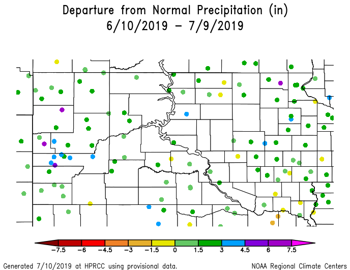
2. Short-term precipitation deficits. Short-term precipitation deficits lead to the drying of the fine fuels and the needle cast/litter on the forest floor. These are the main contributing factors to large fire spread. But we do not have any precipitation deficits in the short term. In fact, flooding has been more of a concern. The top figure shows the observed departure from average precipitation over the past 30 days and the bottom figure shows the radar-derived 30-day precipitation total for the state.


3. Hot temperatures. A continued period of hot temperatures is required to get large wildfire growth during the summer as it contributes to stress and an earlier drying of the fine fuels. Recently, we've seen below average temperatures (top figure) along with those above average precipitation totals. But, as stated previously, we are expecting hot temperatures in the near future (bottom figure). 


4. Available fuels. To get big wildfires, you need fuels that are sufficiently dry to carry wildfire. And this year are fuels continue to be extremely green. The VegDRI product is a good tool to use to determine overall fuel dryness and this year it is showing exceptionally green fuels (figure below). The yellow "pre-drought stress" vegetation condition over portions of western SD is more likely due to a big sweet clover crop that appears yellow to remote sensing tools. The fuels are just not dry enough to support wildfire growth. 


Summary: In short, we are still looking at below average large wildfire potential through the month of July. If the hot temperatures continue this month AND we see below-average precipitation, the wildfire potential might start to climb during August. But the long-term forecasts do not favor that scenario. So get outside, enjoy the hot weather, and always remember to be fire safe regardless of environmental conditions. 


Thursday, May 30, 2019

Alberta wildfires bring smoke to SD

Several massive wildfires are currently burning across northern Alberta with the Chuckegg Creek fire being the largest at 150,000 hecatres (370,658 acres).


These fires are sending plumes of smoke to the southeast where they are impacting air quality and visibility across the north-central US.


The closed 700 mb low over Iowa is bringing northeasterly winds to South Dakota which is allowing the smoke to travel across the state.

And visible satellite really picked up the smoke this morning when the sun angle was low.


May wildfires are not out of the norm for Alberta. Recall the Fort McMurray wildfire of early May 2016 https://en.wikipedia.org/wiki/2016_Fort_McMurray_wildfire.

So if you see or smell smoke across the region, realize it is not of local origin.

Wednesday, May 29, 2019

A wet two weeks

It has most definitely been a wet two weeks across South Dakota with most stations reporting over 200% of their historical averages for the period.
But even this map doesn't tell the whole story. Looking at actual precipitation amounts reveals how wet it actually has been across the state.

Nearly all of western SD has received 2-4 inches more rain than what is average for the period. This has led to widespread flooding near creeks and rivers with significant ponding across the prairies. Fortunately the forecast is calling for relatively dry weather over the next 7-14 days.

Regardless of the upcoming 'dry' period, I do not expect anything close to enhanced fire danger. It's been too wet for too long and the fuels are too green to burn. This wet period will likely keep our fire potential low for at least the next 30 days.