Resources

Friday, September 21, 2018

Fire weather this weekend

Widespread rain was seen over a large portion of SD over the past two days. However, southwestern SD stayed relatively dry (precipitation images below). Thus this forecast will focus on the issues over southwestern SD through the weekend.


Saturday:
High temperatures will be in the mid-80s with minimum RH in the 8-18% range. Westerly winds from 5-15 mph are expected with some gusts to 25 mph possible. Look for mostly clear skies although some altostratus or cirrus are possible. The GFS is showing a very dry lower troposphere and nearly unidirectional westerly winds up the column. There are some 30-knot winds just above the mixed layer and if we can tap into that momentum, we may see some strong gusts at the surface.


Saturday night:
Minimum temperatures will range from 45-55 across the lower elevations and from 55-65 over the higher elevations (yes, it will be warmer over the higher elevations of the Black Hills). Maximum RH recovery will range from 40-50% over those cooler lower elevations and only from 15-25% over the warmer higher elevations. This will precondition the fuels for Sunday.

Sunday:
This will be a pre-cold front day and the forecast will depend on the timing of the frontal passage. But for now, it looks like the front won’t pass southwestern SD until Sunday night which will lead to hot and dry conditions during the day. The forecast as of now calls for temperatures to range from 85-95, minimum RH from 8-18%, and southwest winds from 10-20 mph while gusts to 25+ mph are possible.  Red Flag Conditions are possible. A deep well-mixed layer is forecast which may transport some higher momentum to the surface bringing stronger wind gusts.


Just because we’ve seen drizzle and rain over the past two days over much of SD does not mean it has been wet everywhere! Keep your situational awareness up through the weekend.

Wednesday, September 19, 2018

Much needed rain on the way

The 104 acre Anada fire burned yesterday, 9/18, roughly 25 miles east of Rapid City. This man-caused fire was started from a combine and burned through 2-ft tall grass and was pushed by a 10-mph wind. Peak temperature were in the mid-70s and the minimum RH was near 40%. These conditions led to flame lengths on the head of the fire of 6-8 ft. The weather conditions were far from critical but the fire behavior showed that the fuels were definitely dry and susceptible to rapid fire spread.

The number of days since the last wetting rain is related to the potential for large grass fires. During September if two or more weeks have passed since the last wetting rain, the potential for prairie fire dramatically increases. And as of yesterday, nearly all West River stations hadn't reported a wetting rain in 20+ days with some stations not seeing a wetting rain in over a month. It had been 18 days, 21 days, and 27 days since the last wetting rains at Rapid City Regional Airport, Ellsworth Air Force Base, and Pinnacles RAWS site, respectively. These are the closest stations to the Anada fire and at least represent the conditions on the ground there.

Luckly, rain is on the way. We've already seen a few hundreths of an inch of drizzle/rain over and south of the I-90 corriodor of western SD. Areas farther north of I-90, west of the Missouri River, have seen from 0.20 to 0.50 inches of rain.

The forecast calls for even more precipitation over the next 36 hours. The convection-resolving HRRR weather model shows more precipitation on the way (image below).

In short, this is good news. However, the forecast for precipitation over far southwestern SD does not look nearly as optimistic. And remember that this is an area that has been quite dry over the past 50 days. Critical conditions are not expected in the near future, but if they do develop, we'll have to watch this area of the state for higher fire potential.

Tuesday, September 11, 2018

Critical Fire Weather Conditions Possible on Wednesday (9/12) and Thursday (9/13)

Look for a return of hot, dry, and breezy conditions tomorrow and Thursday which will likely lead to critical fire weather conditions over southwestern SD. Wednesday does look like the most critical of the two days.

Temperatures will be in the upper 80s to mid-90s across the area, minimum RHs will drop to below 20%, and south to southwest winds will be gusty from 15-30 mph.

Wednesday weather forecast images:


Furthermore, these areas of southwestern SD have not seen much for rain over the past 2 weeks with some locales not seeing a wetting rain in over 3 weeks:

The VegDRI product shows much of this dryness across the region.

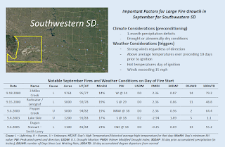
The primary threat will be over southwestern SD as this is where the hottest, driest, and breeziest conditions are forecast to be. The largest 5 fires since 2000 (table below) show similar conditions to what we have seen over the past 2+ weeks and to what we expect to see tomorrow. In short, pay attention and don't get complacent around new ignitions.